Friday, 18 January 2019

Otago Peninsula - Part 1

The Otago Peninsula is home to a large number of unique and endangered species, many of which we saw on our tour with David from Elm Wildlife Tours.  He is a Ph.D. candidate in marine biology and was an outstanding guide. Not only did he know a huge amount of information about the biology and behavior of the animals we saw, he could also spot the smallest indication of an animal’s presence.  This little owl juvenile, for instance, is only 23 centimetres (9 inches) tall but David spotted it from across the road hiding in the crook of a tree.


We spent seven hours on the peninsula, which is part of a crater wall formed by an ancient volcano.  It’s pretty astonishing to find such a wild place filled with unique animals only 30 kilometers (19 miles) from the bustling city of Dunedin.  

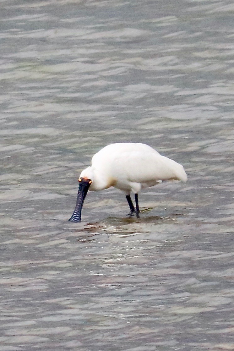
Royal Spoonbill (the spoon shaped part of its bill is under water)


White-faced Heron

One native bird, the red-billed gull, used to be abundant across New Zealand but it is currently endangered due to ocean warming.  These gulls feed mostly on krill but higher ocean temperatures are driving the krill deeper into colder water where the gulls can’t reach them.  The entire species is in decline but the population on the Otago Peninsula is still stable (perhaps due to its proximity to colder arctic waters).  There was a large (and noisy) nesting colony near the tip of the peninsula.

Red-billed Gull Chick

The royal albatross breeds on only one mainland in the world, the Otago Peninsula.  It is breeding season so we got to see these magnificent birds on the nest.  With a wingspan of 3 metres (9 feet 6 inches), the royal albatross is the largest seabird.  Albatrosses spend much of their lives at sea and tracking research has shown that they often circumnavigate the antarctic during their months in flight.  

Albatross breed every other year, laying a single egg. This process takes up to 12 months from nest building to chick fledging.  The population of royal albatross is still considered vulnerable but has had a healthy recovery from a serious decline at the end of the 19th and early 20th centuries. 


We also saw variable oystercatchers, an endemic species (found only in New Zealand), on the nest, which is simply a shallow scrape in the sand, often surrounded by seaweed or driftwood.  This species’ population is considered stable.


Wednesday, 16 January 2019

Sarah Encounters a Poisonous Tree

Hiking to Newtons Waterfall near Akaroa yesterday I brushed my hand against some plants on the edge of the trail and suddenly felt a tremendous sting! Not quite as bad as a wasp sting, but close.  Rubbing my finger hard in a vain attempt to stop the pain, I looked closely at the bush around me and then I saw it – a small tree with long serrated leaves covered in tiny needle-like hairs.  Gradually, the pain receded but a strange tingling sensation continued as my finger slowly went numb.

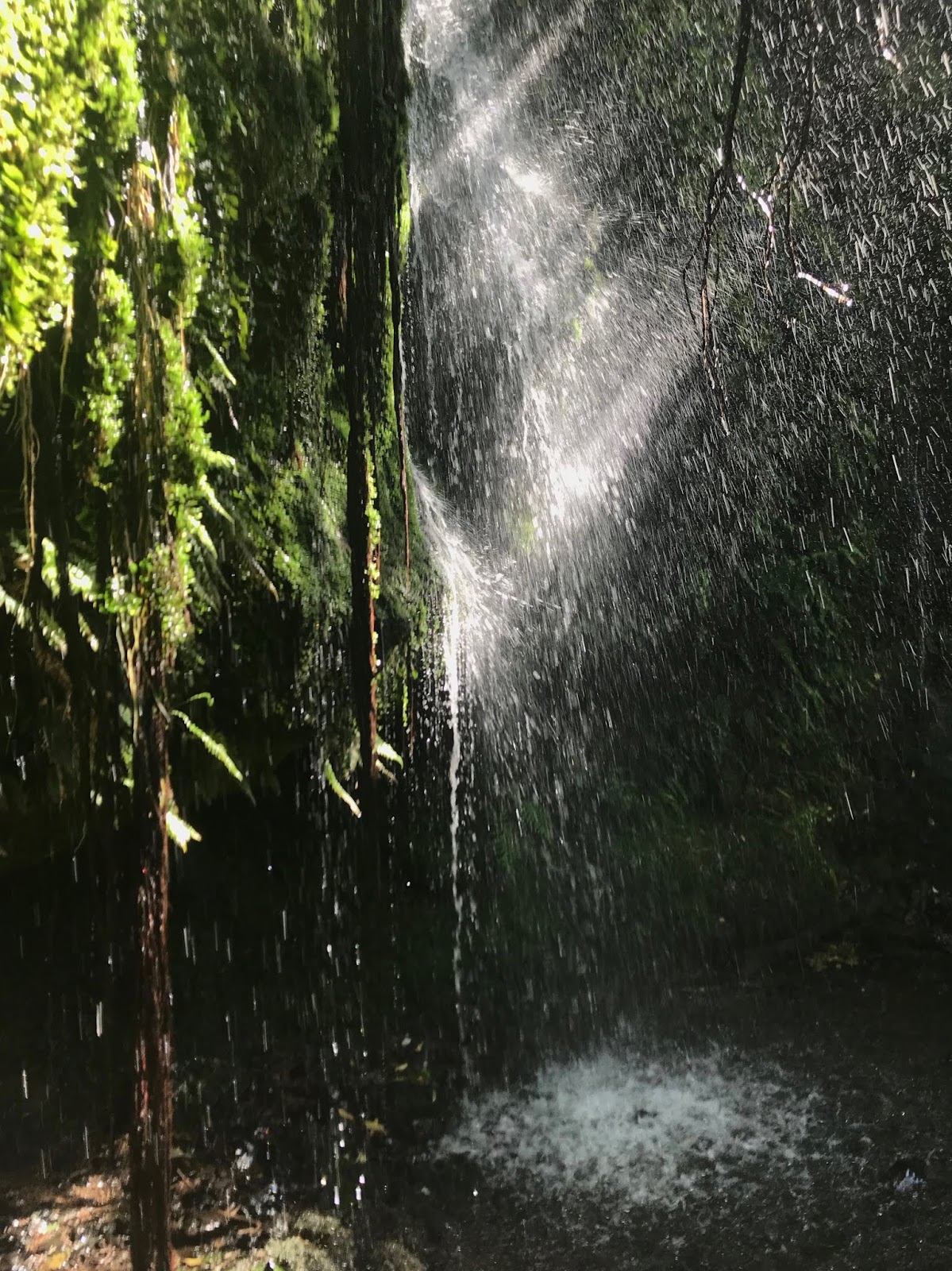
We were a ways out in the bush and except for a numb finger I didn’t have any other symptoms, so we decided to continue our hike.  It was well worth the trip (and even the sting) because the small waterfall was beautiful and perfectly lit by a shaft of sunlight coming through the surrounding trees.  There was even a rainbow reflected in in the droplets of spray.


The rainbow is near the bottom of the falls
              

My finger continued to feel numb and tingly throughout last night but otherwise I felt fine.  Because of the odd symptoms, though, I thought I’d look up this painful tree.  Sure enough, I’d encountered a giant stinging nettle tree, Ongaonga, one of the most poisonous plants in New Zealand. And what I learned about this plant was both reassuring and disturbing.  


Many people develop itchy rashes from being stung by the nettle tree and there are documented cases of both dogs and horses suffering respiratory distress, convulsions, and death from its toxins.  There also is one documented case of a hunter who slipped on wet grass and landed in an Ongaonga patch, getting stung on the legs, face, and hands.  Though he survived, he suffered significant neurological effects including respiratory distress, muscle weakness, confusion, inability to speak clearly, severe cramps, and hypothermia (despite being dressed in wool and down).  His symptoms improved slightly within 24 hours but he continued to be problematic for at least 48 hours and probably longer.  If you want to read the details, here is the link: https://teara.govt.nz/files/d-9773-enz.pdf


Interestingly, an American biomedical scientist, Eric Buenz, who trained at the Mayo Clinic, had his own personal encounter with the giant stinging nettle tree.  As a result of that experience, he has begun to study the plant, hoping to find a way to use its chemicals to manage pain (minus the initial stinging part).  Here’s his story: https://www.stuff.co.nz/science/83197300/painful-native-plant-may-hold-pain-relief-key


As for me, I am totally fine.  This morning as I write this post the tingling and numbness has gradually receded and my finger feels almost completely normal.  My luckily small encounter with this plant has ended up being an interesting adventure in a country where I had no idea there were stinging trees!


Monday, 14 January 2019

Taieri Gorge Railway

The Taieri Gorge train departs from the Dunedin Train Station, which has been called a “gingerbread confection” for its elaborate and grandiose style.  In 2013 Condé Nast Traveller magazine called it one of the top 16 railroad stations in the world.


The Taieri Gorge Line itself dates back to 1879 when construction was begun on a rail link between the Port of Dunedin on the southeast coast and the Central Otago farming communities to the west.  The rail line climbs from sea level at Dunedin to an elevation of 250 metres (820 feet) in Central Otago in just 85 kilometres (50 miles) through a gorge carved by the Taieri River.  There are 10 tunnels and 12 viaducts (in the US we call them trestles – stone and iron bridges crossing deep ravines) on the steep and winding track.

That "tiny" structure in the upper left of this photo is one of the viaducts.  
This photo gives you some perspective on the steepness and depth of the Gorge.


Though we wish we’d had a sunny day, it was still a lovely trip across the plains and then up through the Gorge.


Classic New Zealand farmland with hedges and paddocks


Looking up a deep ravine as we crossed a viaduct


The tops of stone viaduct towers and the track behind us


Sheep are everywhere in NZ, even next to the train tracks


Saturday, 12 January 2019

Lake Wanaka and Mou Waho

We drove to Lake Wanaka on Tuesday the 8thof January. At 192 km (119 miles2), it is the fourth largest lake in New Zealand. Carved out by glaciers about 10,000 years ago, Wanaka is really deep with an estimated depth of 300 metres (980 feet).  It is very pretty with turquoise water, deeply cut walls, and high ridges almost all the way around the lake.  


We took a water taxi to a very special island in the lake, Mou Waho, which is a protected reserve accessible only by boat.  Invasive animals and plants have been eradicated from the island allowing the native plants and animals to thrive.  The endangered Bluff Weka, a flightless bird about the size of a chicken, was once common on the South Island but is no longer due to predation from introduced species such as ferrets and stoats.  However, it has been successfully reintroduced to Mou Waho with a current population estimate of 200 birds.  Some describe the Weka as shy, others say it is curious and will approach humans.  We were lucky to see two while we were on the island and I’d say both descriptions fit this bird.  The ones we saw did approach us but were also quite shy and easily startled; they didn’t hang around for long.  It was exciting to see such a rare bird, even briefly, and I managed to get one decent picture.


Mou Waho is a tall island with a steep path climbing 200 metres (656 feet) to the top.  150 metres up the track is a small lake called Arethusa Pool which is beautiful. 


The last 50 metres of the trail is even steeper but worth the effort. The views from the top are stunning.

The very top of the island


In the photo above, Arethusa Pool is in the foreground.  Lake Wanaka is just behind it and you can also see a sliver of Lake Hawea on the upper left of the photo.  Arethusa Pool contains two small islands.  Each island is on a lake (Arethusa Pool) on an island (Mou Waho) on a lake (Lake Wanaka) on an island (New Zealand) in the ocean.


Wednesday, 9 January 2019

Aoraki/Mt. Cook

**If you haven't figured this out yet, you can 
click on a photo to enlarge it**


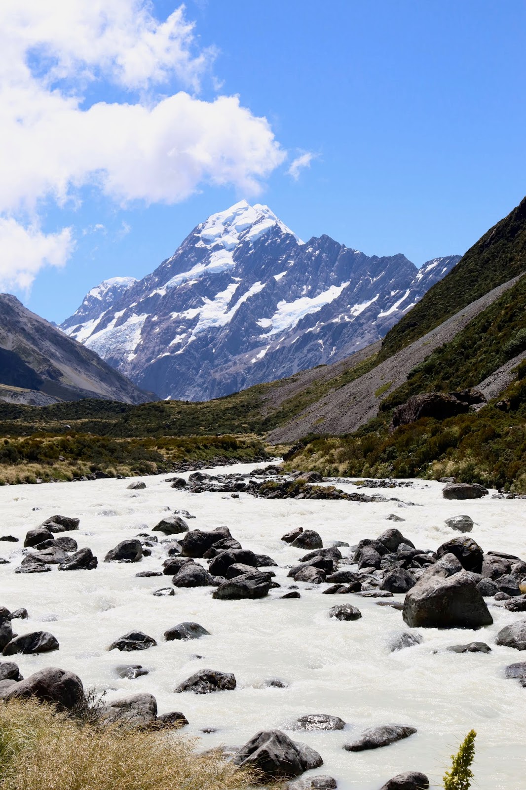
On the 7thof January we hiked the Hooker Valley Track, a very popular route in Aoraki/Mt. Cook National Park.  Aoraki is the tallest mountain in New Zealand.  It is a sacred place for the Maori and one of the most important elements in their creation story.  At 3724 meters (12,218 feet), this magnificent, snowcapped peak towers over the valley where we hiked.  

Aoraki with the Hooker River in the foreground


Just off the trail is Mueller Lake which is at the base of the Mueller Glacier and fed by the Hooker River.  The Hooker is a raging torrent at this time of year and three suspension bridges cross it on this track.  It is quite an experience to walk across these bridges as they bounce up and down and the water roars across the rocks below.


Suspension Bridge

Both Mueller Lake and the Hooker river are white in colour due to the high concentration of extremely fine particles of rock “flour” that is suspended in the water.  The grinding of glacial ice on stone creates this finely ground powder which is then washed into lakes and rivers.  Eventually these particles are dispersed into larger lakes, such as Lake Pukaki, which we drove by on the way to the Hooker Valley Track.  At lower concentrations in these bigger bodies of water, the tiny bits of rock reflect the blue of the sky causing the lakes to appear an amazing shade of bright turquoise.


Lake Pukaki


Glaciers above Mueller Lane


There were quite a few beautiful wild flowers along the trail.

Mountain Daisy (the flowers look like a daisy but the foliage is totally different)


Wild Foxglove - I've never seen this in the wild before 


This flower, which I was unable to identify, is growing right on top of the rock


And one last shot of Aoraki:


Monday, 7 January 2019

Lake Tekapo

We just spent a couple of days in Lake Tekapo which is about half-way down the South Island in the Otago region.  The area is full of massive mountains surrounding placid, warm valleys full of cows and sheep.  We’re actually having what feels like a heat wave – it has been 30C (86F) the last two days - though we’ve been told that this is pretty typical summer weather for the region. We’re loving it after leaving a very cold Minnesota a week ago.  

One of the reasons to visit Lake Tekapo is for its dark sky – it is actually one of the darkest areas in the world and the night sky has been marvelous.  I haven’t seen stars like this since I was a child.  Another reason to come to Tekapo is the hiking. Yesterday we did a stunning alpine hike to see Aoraki (Mt. Cook), the tallest mountain in New Zealand.  But you’ll have to wait until the next blog post to see those photos.  Today it’s all about Lake Tekapo.

It was raining when we arrived at Lake Tekapo giving this image a watercolour effect.


Just before sunset the weather cleared and the fog began to roll down this mountain saddle.


As the sun set, sky became an incredible shade of pink, 
which was also reflected in the water of the lake.

Thursday, 3 January 2019

Christchurch City


Today was our first day in Christchurch, NZ and we spent some happy hours wandering through the Central Business District (CBD), enjoying the tremendous growth and vitality of an area that was basically completely destroyed in the earthquakes of 2010 and 2011.  The picture below was taken in 2015 and shows a fairly typical post-earthquake building.  In the CBD, these sites were interspersed with empty lots or piles of debris.


Since then there has been what feels like a magical transformation.  Where we once walked by empty block after empty block interspersed with construction sites, there are now many modern, beautiful, earthquake-safe buildings.  Downtown was so damaged that few people ventured there in 2015 but today it was crowded with visitors and locals enjoying the newly opened museums, lovely parks, and wonderful restaurants and cafes.  The energy and vitality were a joy to experience, especially after the dreary and often sad surroundings of 2015.

The Christchurch Art Gallery Te Puna o Waiwhetū


The Piano, Centre for Music and the Arts


A flooded ruin - much of the CBD looked like this in in 2015

The saddest note today was to see that Christchurch Cathedral is still a ruin and has barely been touched by any restoration activity (the crane next to it gave us some hope that work is underway or will be soon).  Restoring the cathedral has been a massive controversy.  Though it is the heart of Christchurch and deeply connected to the original European settlers, the cost to repair the church is far beyond its value.  The Anglican Church and City of Christchurch have spent years debating the feasibility of the project and final agreement to restore the cathedral wasn’t made until June of 2018.  The repair work will take about ten years to complete at a current cost estimate is $104 million dollars.


2020 Trip Canceled

Dear Readers, due to a family health situation, we have had to cancel our trip to Australia this year.  I'm happy to report that the sit...